
-
-
-
-
-
-
-
-
-
-
-
-
-
Alabama
-
-
-
-
-
-
-
-
-
-
-
-
-
-
-
-
| Map of the Bartram Trail |
 |
|
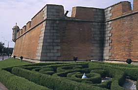
| Fort Conde Visitor Center, Mobile |
Trip to Mobile, 1775
According to the late Peter Brannon,(124) the trail led him west from Coweta, below the junction of Little Uchee and the Big Uchee Creeks and by what is now Knuckles’ Bridge. He joined the present Columbus to Eufaula highway at the old Double Branches crossing (about a mile west of Big Uchee Creek bridge). From there he passed Old Fort Bainbridge, Creek Stand, Warrior Stand, and the future site of Fort Hull (1813). He apparently left the trail in the vicinity of Persimmon Creek in order to visit Tallassee. Perhaps the traders were headed there. From Tallassee, on the north bank of Euphaupe Creek at its junction with the Tallapoosa River, he proceeded down the east and south bank of the Tallapoosa to Coolome, some twelve miles east of Montgomery. Traveling in a southwesterly direction, Bartram’s party would have passed the present sites of Mitylene, Oak Grove Church, and Pinedale. The night’s camp was probably in the vicinity of Snowdoun.(125) From here they continued south and west across Pinchona Creek (crossing the present Mobile Highway US 31 half a mile north of Moseley’s Store).
 |
|
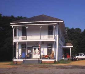
| Burnt Corn post office and general store |
While in the Mobile country, he visited Pensacola, made trips up the Tombigbee for a short distance, and spent some time with Major Farmer, former British governor, at his plantation on an island near the head of the Delta.
Bartram described Mobile as “extending near half a mile back on the level plain above” the river:
“It has been near a mile in length, though now chiefly in ruins, many houses vacant and mouldering to earth; yet there are a few good buildings inhabited by French gentlemen, English, Scotch and Irish, and emigrants from the Northern British colonies. Messrs. Swanson and McGillivary who have the management of the Indian trade, carried on to the Chicasaws, Chactaws, Upper and Lower Creeks, &c. have very extraordinary improvements in buildings.”(126)
He specifically mentions Fort Conde (now restored) “which stands very near the bay, towards the lower end of the town” calling it “a large regular fortress of brick.”
Incidents of the Trip
The discovery of a she wolf and her pack of cubs, mentioned in the journal, probably took place at a point in Montgomery County south of the city near where the present road which leads from the Woodley Road west to Snowdoun. He describes one of the wolves which was caught and killed “as half the size of a small cur dog and quite black.”(127) A present-day resident in the central part of the State can very easily interpret Bartram’s description of his travel route. Shortly after leaving Coolome, he refers to the country as consisting of “expansive illumined grassy plains;(128) he saw the upper stratum as perfectly black, soapy and rich, especially after rains, which rendered the road very slippery. He described these rich lands as “living on a deep bed of white testaceous limestone rock which in some places resemble chalk and in other places are strata or subterrene banks of various kinds of sea shells, as ostrea, etc.”(129) As the road left the prairie country it entered a “grand high forest”(130) filled with oak, ash, sour wood, sweet gum, beech, red maple, chestnut, and pines. He had now entered present-day Butler County and travelled along Fort Dale Road. A little further on he found a great dogwood forest, between nine and ten miles in width. This was in the central part of Butler County in an area known today as Pine Flat.
Return Trip to Georgia, 1775
Bartram’s return to Georgia began in November, 1775 (not 1777 as he records in Travels), “in a large boat with the principal trader of the company.”(131)
At Taensa, Bartram loaded his horse (which he had left with a friend in the Mobile Delta area during his Gulf Coast travels) with his personal effects and:
“…some presents to the Indians, to enable me to purchase a fresh horse in case of necessity, for my old trusty slave which had served me faithfully almost three years having carried me on his back at least six thousand miles, was by this time almost worn out.”(132)
 |
|
| Fort Toulouse, Elmore County |
Footnotes
122. Bartram’s Travels, p. 388, Harper, p. 245.
N.B. Page numbers for all Bartram quotations will be given in the following way: The first page number cited will be the page on which the passage appears in the first (Philadelphia 1791) edition of the book; the second page number will be the page on which the passage appears in Francis Harper’s Naturalist’s Edition. For convenience in checking the original source, Harper’s edition provides both systems of pagination. When third or fourth numbers appear, they refer to Harper’s commentary, also in the Naturalist’s Edition.
123. Ibid., p. 396, Harper, p. 251.
124. For much of the information contained in this account of Bartram’s travels through Alabama, the Bartram Trail Conference has relied on the research of Dr. Peter A. Brannon co founder and first president of the Bartram Natural History Society (1916). His thorough research on William Bartram was recognized by Francis Harper and other Bartram scholars and appeared in newspaper, magazine and journal articles. The information used here appeared in the Montgomery Advertiser on June 25, 1939. The Conference in indebted to Mr. Milo Howard, director of the Alabama State Department of Archives and History for drawing it to our attention.
125. Harper, Naturalist’s Edition, op. cit., p. 402.
126. Bartram’s Travels, op. cit., p. 404, Harper, p. 256.
127. Ibid., p. 398, Harper, p. 252.
128. Ibid.
129. Ibid., p. 399, Harper, p. 253.
130. Ibid.
131. Ibid., p. 440, Harper, p. 278.
132. Ibid.
133. Ibid.
134. Dr. Peter Brannon, op. cit.
135. For Bartram’s own explanation see Travels, op. cit., pp. 441–442, Harper, p. 279.
136. Ibid., p. 348, Harper, p. 277.